
The city divided by the river is further divided by racial and lingual differences. —Nelson Algren, Chicago: City on the Make
[Richard J. Daley] grew up a small-town boy, which used to be possible even in the big city… Chicago, until as late as the 1950s, was a place where people stayed put for a while, creating tightly knit neighborhoods, as small-townish as any village in the wheat fields.The neighborhood-towns were part of larger ethnic states. To the north of the Loop was Germany. To the northwest, Poland. To the west were Italy and Israel. To the southwest were Bohemia and Lithuania. And to the south was Ireland. —Mike Royko, BOSS: Richard J. Daley of Chicago
Chicago is a city of neighborhoods, and I love that. It’s cool to have different foods from all over the world within a stone’s throw of my house. —Rick Bayless, Food and Wine interview
In Chicago, novelists, politicians, and chefs can agree on one thing, perhaps only one thing: Chicago is a city of neighborhoods.
Most cities are, you might say. Yes, of course. Most cities are aggregations of small-town-like neighborhoods, characterized by geography (Uptown), ethnicity (Greektown), economy (Printers’ Row), or history (Bronzeville). But Chicago, with its mile-square gridding (a powerful remnant of the Northwest Ordinance of 1787) and its flat, expansive geography (with the lake severing one edge of the city’s otherwise level endlessness) lends itself particularly well to being parsed into neighborhoods.
Chicago has long capitalized upon its neighborhoodgoodliness. In 1942, the Chicago Plan Commission (CPC) published Forty-Four Cities in the City of Chicago. Another CPC report, Building New Neighborhoods, published the following year, proposed new subdivision design standards and redevelopment strategies with the stated purpose of making “surburban-style residences in the city that would keep Chicagoans in Chicago.”1
This is the same Chicago Plan Commission that was formed in tandem with the publication of Burnham and Bennett’s Plan of Chicago of 1909. Then-mayor Fred Busse appointed 328 men, representing the city’s business and social interests, to promote The Plan’s vision and implementation. From one city to forty-four in thirty-three years: “Make no little plans” had become “Make a whole lot of little cities.”
Backlash to Burnham’s Plan began almost immediately. Already in 1911, landscape architect Jens Jensen described it as “inhuman, imperialistic, and undemocratic.”2 Historian Donald Leslie Johnson echoes that sentiment when he writes, “To reformers and most progressives the Plan was seen as a flagrant attempt to use tax monies for aggrandizing self-serving politicians and their aristocratic plutocracy, as exemplified by ward bosses and the merchant princes of the Commercial Club.”3
“Organize the whole” versus “breakdown the parts” remains a dichotomy that’s all too familiar: singular versus plural; imperial versus democratic.
Cities can’t be reduced to binaries. Sure, it’s easy to focus solely on one of Jules Guerin’s bird’s-eye views of the 1909 Plan. These watercolors dramatize Burnham and Bennett’s baroque boulevards, centering on the colossal Civic Center. But The Plan’s brilliance is that it introduced multiple scales: regionally scaled forest preserves, a city-scaled park along the waterfront, and playgrounds dispersed throughout the city. 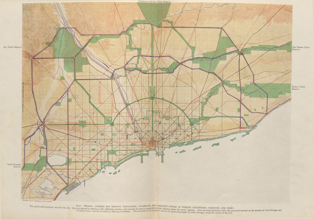
Burnham’s mandate “Make no little plans; they have no magic to stir men’s blood” did not mean that The Plan overlooked the small: It merely absorbed many plans into its multi-scalar logic. It’s one of three multi-scalar planning visions that form a counter-history to the prevailing assumption that Chicago can only be thought of as a city of neighborhoods: the Burnham Plan, Frank Lloyd Wright’s Quarter Section “Non-Competitive Plan,” and Reginald Isaac’s plan for the city’s Near South Side.
Resistance to The Plan’s singularity unmoored a flotilla of smallness in Chicago, culminating in the hundreds of neighborhoods used by today’s real estate maps of the city. While the American planner and sociologist Clarence Perry is widely credited with coining both the concept and the term “neighborhood unit” in a study he did for the Regional Plan Association in 1929, already in 1913 the Chicago City Club sponsored a competition for urban design promoting a neighborhood urbanism of the “quarter section”—a quarter mile square, or 160 acres. The terms of the competition defined a community or neighborhood as being primarily residential, with a bit of civic and commercial use added in. The imaginary site, which was eight miles from Chicago, did not include work, as it was connected by rail to places of work.4 In short, the competition promoted an idealized urbanism that was but a fraction of a city.
While some of the proposals isolated these fractions from their surroundings, creating independent mini-cities foreshadowing cul-de-sac suburban planned developments all too familiar to us today (the most extraordinary version being the snowflake-like plan submitted by Louis H. Boynton), several schemes (G.B. Cone, William Drummond, and others) capitalized on Chicago’s generous grid, creating new urban subdivisions that were integral to, rather than isolated from, the city. 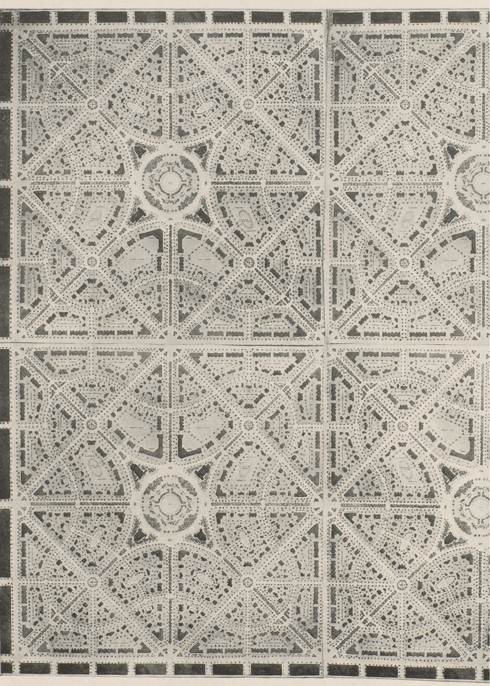
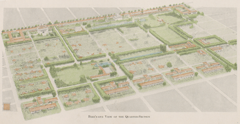
Wright’s design maintained the overriding orthogonality of the Chicago grid system but eschewed monotony by introducing what he called “picturesque variety.” He introduced the “quadruple block plan,” which adopted a square rather than rectangular block subdivision for The Plan’s single-family homes. By placing only four houses on a single small block, Wright was able to offer each house its own orientation. He rotates the four around an inner core of shared utilities, thereby guaranteeing a degree of privacy while also ensuring visual variety:
His building is in unconscious but necessary grouping with three of his neighbors’, looking out upon harmonious groups of other neighbors, no two of which would present to him the same elevation even were they all cast in one mold. A succession of buildings of any given length by this arrangement presents the aspect of well-grouped buildings in a park, of greater picturesque variety than is possible where façade follows façade.5
Wright created a picturesque relationship between buildings and park without sacrificing the grid or green space. An internal park system, financed by the sale of the residential property, weaves its way through the subdivision, ordering recreational features such as playgrounds, athletic fields, and a music pavilion. Balanced, although not entirely symmetrically, around a diagonal axis across the site, the park subtly segregates the residential from the civic and commercial sections of the subdivision. It also differentiates residential zones of seven- or eight-room houses, two-flat buildings, workmen’s houses, and women’s and men’s apartment buildings. With this park, Wright’s proposal surpasses both the tower in the park and suburban residential development strategies. The park reaches to the edges of the superblock, but unlike the green carpets that Le Corbusier would design a decade later, this one is strategically programmed: It combines low-rise and medium-rise densities with non-residential programming to perpetually animate the entire subdivision. While the park system blocks some streets, it never creates cul-de-sacs and refuses to turn its back on Chicago.6 While Wright’s Quarter-Section Plan for the 1913 Competition was never executed, it demonstrates how development can work within the logic of the Chicago grid without being entirely subsumed by that grid: Wright’s scheme offers an urbanism of its own that emerges from the larger gridded urbanism within Chicago’s DNA.
Both Burnham and Wright did not so much defy the neighborhood unit (which was not yet even coined as a term when they were developing their projects) as animate and even deliberately agitate the neighborhood-city relationship. The residential areas that they both envisioned were not isolated from the broader context of the city; they were not proposing self-sufficient islands but rather smaller-scaled pieces of the city that were dependent upon yet other pieces of the city, which in turn, depended upon them.
Writing at the end of the 1940s, planner Reginald Isaacs, who was then director of the planning staff of Michael Reese Hospital in Chicago and would go on to chair the planning department at Harvard, was appalled by the prevailing obsession with neighborhoods.
He was particularly struck by the failure of the neighborgoodlies to recognize the impossibility of reproducing a rural community within an urban environment.7 Rural communities typically center on a single school and a single church, and their attendant, relatively homogeneous population. For urban organizations, on the other hand, such homogeneity is not only less likely but also anathema to what a city is—a mash-up of vibrant (if unpredictable) cultural exchanges.
While Isaacs was the most ardent critic of neighborhood planning, he wasn’t alone in spotting an incompatibility between the neighborhood ideal and the urban real: As Perry’s neighborhood unit reached its twentieth anniversary, it was reviewed by sociologists, architects, planners, and historians. In a nuanced article laying out the complexities of urban neighborhood planning, Lewis Mumford acknowledged that it was relatively easy to plan communities as suburban bubbles but far more challenging to integrate them into a larger urban fabric.8 Isaacs furthered this argument, honing in on a more volatile kind of integration: “The neighborhood,” he wrote, “is an excellent device and framework for the organization and enforcement of covenants and deed restrictions against FHA’s inharmonious groups. Today, the fear of minority group infiltration is substituted for a common denominator of neighborhood consciousness.”9 Isaacs recognized that neighborgoodliness could be deployed as a seemingly innocent cover for discrimination; the May 1948 Supreme Court case Shelley v. Kraemer was a unanimous ruling declaring that a court may not constitutionally enforce a “restrictive covenant” that prevents people of certain race from owning or occupying property. Isaacs posited that without that tool, fearful residents would turn to claims of neighborhood and community “definition” to prevent integration. His assumptions were not unfounded. The developer J.C. Nichols, who had largely depended on restrictive covenants in drawing up the deed restrictions for his suburban developments around Kansas City, wrote with all sincerity in a Time magazine article that “when you rear children in a good neighborhood, they will go out and fight Communism.”10 As Isaacs noted in response, “[Nichols] is representative of many who, disregarding the mobility of urban life, say that the Negro, Pole, Jew, Mexican, Italian, and other ‘inharmonious’ persons shall continue to live in his confined ghetto and that the neat division of a ‘neighborhood’ unit around him is just what is wanted.”11
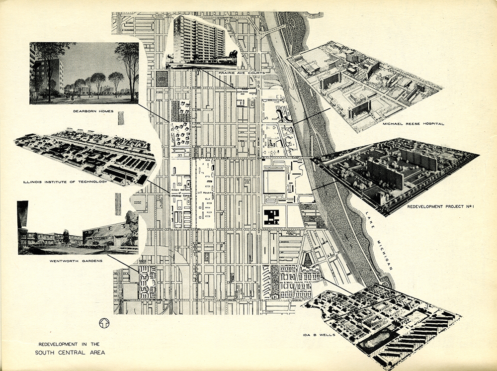
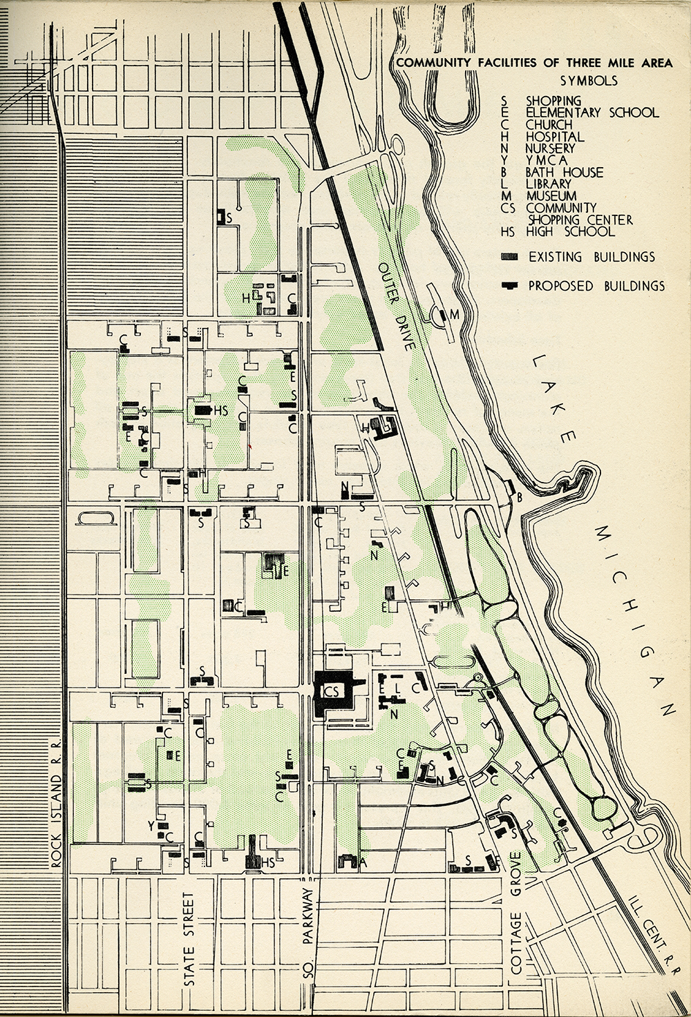
But if not neighborhood planning, then what? As planning director of Michael Reese, Isaacs was deeply involved with Chicago’s Near South Side Plan, one of the few truly modern plans to be implemented in the United States. The South Side Planning Board, which was founded in 1946, was a nonprofit organization initiated by IIT and Michael Reese Hospital that architecture critic Ada Louise Huxtable described—with clear astonishment—as being composed of “Catholic, Protestant, Jewish, Negro, Labor, Railroad, Industrial-Commercial, Real Estate, and Public Housing” interests, all focused on the replanning of a seven-square-mile area of Chicago just south of the Loop.12 The South Side Planning Board wasn’t a government entity; it wasn’t an elected body; it had no given powers. In short, the SSPB was the very model of the civic associations that had so fascinated Alexis de Tocqueville in his trip across America a century earlier: As he had noted, these uniquely American societal organizations enabled, channeled, and also masked various interlocking regimes of economic and political power. The South Side Planning Board was an alliance of academics from IIT and the University of Chicago, business leaders from Chicago’s Loop, and neighborhood clergy and community organizers, even including the editor-in-chief of the Chicago Defender, the country’s most prominent black newspaper. The Board’s resulting Near South Side Plan, developed and partially implemented over the span of about a decade, transformed the area that Huxtable pointedly called the largest slum in North America into a district of modern campuses that included, in addition to IIT and Michael Reese Hospital, a Catholic school, public housing, private housing, and a shopping center.
Each institution’s boards (the hospital, the university, the Chicago Housing Authority) were, like the South Side Planning Board itself, composed of different but overlapping constituencies. Each campus varied the building types on its land, lend-ing each the feel of a small city. Because none of the campuses was fenced, the entire seven-square-mile area had this same varied quality. Housing campuses combined townhouses, rowhouses, and slabs, ranging from seven to fourteen stories high, and included small community buildings. Institutions, whether the hospitals or the university, were collections of buildings. Landscape architects who collaborated on The Plan included Hideo Sasaki and Alfred Caldwell, among others. As with Frank Lloyd Wright’s Quarter Section scheme and the Burnham Plan, The Plan’s components—and each separate campus’s components—were connected by a fluid, landscaped system, including defined gardens, playgrounds, and green circulation arteries, and collecting the entire South Side Plan into a dynamic whole.
As the Near South Side’s various campuses stretched and reached into one another, they also stretched and reached into the city’s existing grid. Platted in 1830, Chicago was squarely set within the gridiron tradition systematized by Thomas Jefferson’s 1785 Northwest Ordinance, which subdivided the Western Territories into townships of thirty-six square miles. This gridded system divided the landscape into commodifiable parcels, thereby facilitating rapid (and rampant) land speculation. Despite the implied rigor of the grid’s mathematical substrate, Chicago’s blocks are not entirely homogeneous:
The blocks may be made 300 feet square, and usually not over 320 feet by 400 feet, with a 20-foot alley running the long dimension of the block. The principal streets are usually made 80 feet in width, though frequently as much as 100 feet where the greater width appears to be needed or desirable, and the less important intersecting streets are seldom given a width of less than 60 feet. An alley is usually placed in each block, 20 feet in width and paralleling the principal street system… Unless planned differently, the whole system is laid out on cardinal directions…13
The term usually, oft repeated within the pages of The Manual of Surveying Instructions, suggests regularity but admits aberration. If New York’s unyielding grid “forces Manhattan’s builders to develop a new system of formal values, to invent strategies for the distinction of one block from another,” Chicago’s is essentially the opposite: The grid itself is manipulated in order to distinguish one project from another.14 Because Chicago emerged from a territorial organization (unlike Manhattan’s, which is limited to its island configuration), its logic lies at a scale much greater than its urbanism—and this telescoping between the Jeffersonian grid and local practices of subdivision resulted in nonstandard parcelization: The “usual” Chicago block is 266 by 600.15
The campus projects that defined the Near South Side Plan were all bigger than the usual block, but the consolidation of plats through different means of land aggregation (ranging from backroom transactions to inaugural urban renewal legislation passed at the Illinois state level) was done with the conviction that the urban environment could (and should) foster a different kind of urban citizen—a citizen living in and defining an emancipated city-state.16
And that’s precisely the challenge of urban design: It is easier to see cities as agglomerations of villages, perfected atolls, securing our identities and ideals. But overconfidence in where “we” live and work as being different from where “they” live and work is more than risky. It balkanizes the social contract. It places the city as a whole at risk.
Chicagoans may coalesce around their various sports teams, but do they ever really coalesce around a broad understanding of how the city defines them as members of an urban public? The continued and extreme violence in the Englewood/South Side areas of Chicago over recent years has intensified anxiety regarding the city and a greater desire to differentiate “safe” neighborhoods from those zones of violence, echoing some of the discriminatory sentiments that Reginald Isaacs noted more than sixty years ago.
The campuses built in the ’40s and ’50s as part of the Near South Side Plan— IIT, Michael Reese Hospital, Mercy Hospital, Lake Meadows, Prairie Shores, Prairie Avenue Courts, Dearborn Homes—did not “take” as a model. With a few exceptions, including Carl Sandburg Village developed north of the Loop in the 1960s, most of the housing, public and private, of the ’60s was singular in its typology, particularly the vast arrays of homogeneous towers (Stateway Gardens, Robert Taylor Homes) that came to symbolize public housing in Chicago. Why didn’t the model continue? How much did its demise depend upon the fact that the advocates moved on? Henry Heald, the president of IIT, left to become chancellor of New York University and later the head of the Ford Foundation; Mies stepped down as head of architecture at IIT; Reginald Isaacs left Michael Reese for Harvard; Martin Meyerson left the University of Chicago for Penn; and Elizabeth Woods, the outspoken head of the CHA, was ousted for her pro-integrationist stances. The devastating effect of this cast-change at the South Side Planning Board reveals the vulnerable flipside to American urbanism’s dependence on civic associations. The rich variety and connectivity that had marked the Near South Side’s projects, what I have referred to elsewhere as a “bas-relief urbanism,” disappeared.17 This lively bas-relief had constantly reminded the collective public inhabiting its seven-square-mile area that they didn’t belong to one building but many; not to one campus, but an area; not to one neighborhood, but to a city.
Have architects and urban designers become numbed by the seductive salve of the neighborhood unit? Have we become fearful of the social contract itself? Is the “making of no small plans” taboo today? Is there, in fact, an urbanism of the neighborhood today? Or, for that matter, of the city?
It’s a particularly urgent moment now to confront these questions by looking back on the multi-scalar experiments of the Burnham Plan, Wright’s Quarter Section Plan, and the Near South Side Plan. The evidence of the experiment on the Near South Side is fast disappearing: Keck and Keck’s Prairie Avenue Courts has been demolished; Michael Reese is being demolished; and historicist townhomes have sprouted up on the Lake Meadows campus, with rumors that the SOM-designed slabs will be torn down. Similar historicist townhomes have replaced the Robert Taylor Homes and Stateway Gardens already, as the city has shifted its public housing strategy to HOPE VI mixed income, New Urbanist-inspired developments. While the mixing of incomes is laudable, the program’s admitted inability to replace, one to one, low-income housing stock availability repeats one of the social support crimes of urban renewal: The density of the slums was not replaced with an equal density of modern public housing. The concomitant shift from modernism to historicism makes modernism the straw man in this complicated story.
It’s remarkable how few urban planners and designers have really taken on the challenge of designing modern, metropolitan living. As we move decidedly into the twenty-first century, the anachronism between our conception of the contemporary subject and our concept of the contemporary city becomes ever more pronounced. To offer alternatives to neighborgoodlies is not to eliminate the significant role of the immediate or intimate scale. Each urban citizen constitutes his or her city out of overlapping environments and experiences, particularly now that the virtual world has become such an integral part of our everyday lives. It’s much like political philosopher Nancy Fraser’s understanding of the public sphere: It’s not a singular realm that operates in a binary relation with the private sphere. Instead, the public is constituted of multiple publics—different constituencies that constantly overlap, morph, combine into additional constituencies, all of which both form public discourse and also constantly challenge it.18 In other words, despite desires to bracket people into singular and often binary categories (Democrat/Republican, male/female, white collar/blue collar…), it’s impossible to keep people so tightly parsed in the same way and for the same reasons that it’s impossible to keep neighborhoods so tightly parsed. In recent writing, Fraser has taken on the challenge of understanding the effect of transnationalism upon this understanding of the public sphere. The loosening of the singular relationship between the sovereign state and its citizens makes it difficult to see how any publics can engage in an effective political discourse: “If the modern territorial state no longer possesses the administrative ability to steer ‘its’ economy, ensure the integrity of ‘its’ national environment, and provide for the security of ‘its’ citizens, then how should we understand the capacity component of efficacy today?”19 In this recent work, Fraser sees the contemporary challenges of fluid national borders, fluid ideologies, fluid media, but also the challenge of the engines behind access to information and the opinions that follow.
Scaling Fraser’s argument down from national considerations to neighborhood ones, the parallels are striking. Pan-city activism (race, crime, income disparities) is ever more urgent. By reinforcing urban identity as being concentric with neighborhood definition, we overlook both the construction of neighborhood identity (which stems as much from place as it does from real estate and media manipulation) and the possibilities of overlapping identities and influences that render publics and urban politics far more profound. Fraser’s public is a polyvalent one; it’s imperative that we design that public’s polyvalent city.
-
Carl Smith, “The Plan of Chicago: Heritage,” in the online Encyclopedia of Chicago, link. Also see Chicago Plan Commission, Building New Neighborhoods: Subdivision Design and Standards (July 1943). ↩
-
From “Regulating City Building,” The Survey, November 18, 1911, 13–14, quoted in Gwendolyn Wright, Moralism and the Model House (Chicago: University of Chicago Press, 1980), 263. ↩
-
Donald Leslie Johnson, “Origin of the Neighbourhood Unit,” Planning Perspectives 17 (2002): 229. ↩
-
A.B. Yeomans, ed., City Residential Land Development: Studies in Planning, Competitive Plans for Subdividing a Typical Quarter Section of Land in the Outskirts of Chicago (Chicago: University of Chicago Press, 1916). ↩
-
Frank Lloyd Wright, “Plan by Frank Lloyd Wright,” in Yeomans, City Residential Land Development, 99 (emphasis Wright’s). ↩
-
Albert Pope, Ladders (Princeton Architectural Press and Rice School of Architecture, 1996). ↩
-
Reginald Isaacs, “Are Urban Neighborhoods Possible?”, The Journal of Housing, vol. 5, no. 7 (July 1948): 178. ↩
-
Lewis Mumford, “The Neighborhood and the Neighborhood Unit,” Town Planning Review, vol. 24, no. 195 (1953/54): 261. ↩
-
Reginald Isaacs, “The Neighborhood Theory: An Analysis of Its Adequacy,” The Journal of the American Institute of Planners (Spring 1948): 19. ↩
-
“The Country Clubber,” Time, December 1, 1947, as quoted in Isaacs, “Are Urban Neighborhoods Possible?” 178. See Sara Stevens’s Developing Expertise: Real Estate and Architecture in Metropolitan America (forthcoming 2016 from Yale University Press) for more about Nichols and other American developers. ↩
-
“The Country Clubber.” ↩
-
Ada Louise Huxtable, Two Cities: Planning in North and South America, Museum of Modern Art. Exh. #352, June 24– September 21, 1947. ↩
-
Bureau of Land Management, The Manual of Surveying Instructions of 1947 (Washington, D.C., 1947), 352 [emphasis added]. ↩
-
Rem Koolhaas, Delirious New York (New York: Monacelli Press, 1984), 20–21. ↩
-
Homer Hoyt, One Hundred Years of Land Values in Chicago: The Relationship of the Growth of Chicago to the Rise in Its Land Values 1830–1933 (Chicago: University of Chicago Press, 1933), 428–29. ↩
-
Please see my “Bas-Relief Urbanism: Chicago’s Figured Field,” in Phyllis Lambert, ed., Mies in America (Harry N. Abrams, 2001), 642–91, for a more detailed explication of the means by which plats were assembled into large parcels for these projects. ↩
-
For a more extended discussion, please see my “Bas- Relief Urbanism.” ↩
-
See Nancy Fraser, “Rethinking the Public Sphere: A Contribution to the Critique of Actually Existing Democracy,” Social Text 25/26 (1990): 56–80. ↩
-
Nancy Fraser, “Transnationalizing the Public Sphere,” in Kate Nash, ed., Transnationalizing the Public Sphere (Polity Press, 2014), 32. ↩
Sarah Whiting is William Ward Watkin Professor and Dean of the Rice School of Architecture and a partner of WW Architecture, based in Houston.