
At a bar in Bodrum, Turkey, one summer evening in 1958, a young American journalist named Peter Throckmorton struck up a conversation with some local fishermen. Or, as he later wrote, “After the third shot, the captain began to talk.”1 Throckmorton—a writer, photographer, and amateur diver—came to Turkey after hearing news that a bronze statue of the ancient Greek goddess Demeter had been pulled up by sponge divers. He hoped to get a story out of his trip and perhaps make a few discoveries of his own. Some five years later he published a book about his experience that reads like an adventure novel à la H. Rider Haggard. In his account he explains that between swigs of Turkish raki, sponge fishermen told him the Aegean was brimming with ancient wine vessels and the biggest piles of them were located along the coast of an island called Yassiada (“flat island”). The experienced seamen made fun of Throckmorton’s many diving gadgets and were surprised by his enthusiasm for old broken pots. They complained that the vessels—called amphorae—often got stuck in their nets. Throckmorton was so excited by this news that he begged the fishermen to take him to Yassiada the next day to see the pots for himself. 2 The rest is history—that raki-infused night in Bodrum would lead to decades of research in the area continuing to today.
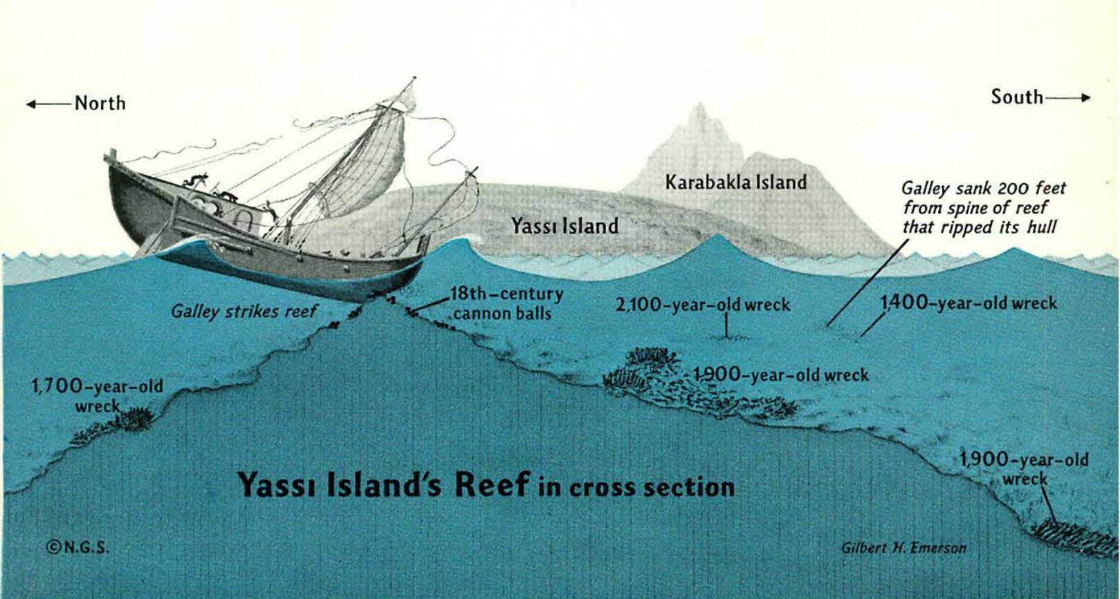
That summer, Throckmorton had no funding to do a survey or proper research, but with the sponge divers’ expertise he located many wrecks in the area. Yassiada was especially rich with shipwrecks due to the sharp shallow reef hidden just below the waterline on its coast.3 In addition to the knowledgeable sponge fisherman, Throckmorton also had the good fortune of meeting a diver and draftswoman named Honor Frost, who happened to be traveling through Turkey at the same time. She had experience with archaeological digs on land and came to Bodrum with her diving gear—interested in developing techniques for drafting underwater, she knew the area would have plenty of wrecks to experiment on.4
Over the next two years she and Throckmorton mapped the locations of numerous wrecks and produced preliminary drawings of various sites. Frost writes about their strange position as experts without official archaeological credentials: “We realized it was easier to find wrecks than to persuade first-rate professionals to produce rational excavation methods … Success depended on our ability to present the evidence and raise interest in the project.”5 Between Frost’s early survey drawings and Throckmorton’s underwater photographs, they had enough visual evidence to garner funding for future research and to convince experienced archaeologists to get involved. Throckmorton took their documentation back to the United States, where he got the attention of the University of Pennsylvania.6 The University Museum sent an archaeologist named George Bass (fresh from a YMCA diving class in Philadelphia) to Turkey to plan and execute a series of excavations with Frost and Throckmorton.7
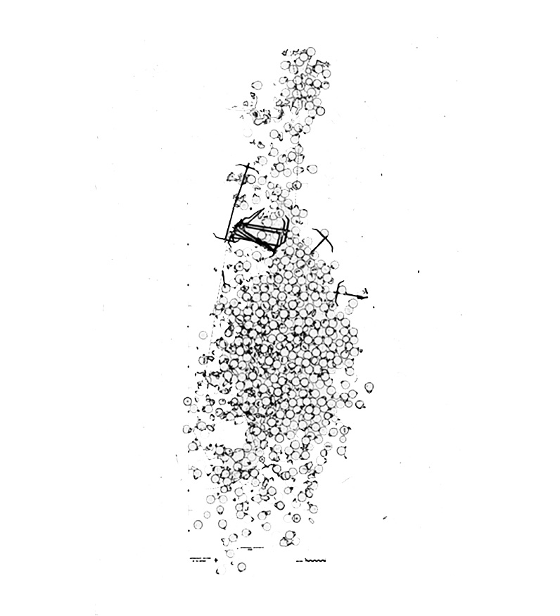
Though Frost and Throckmorton identified many wrecks at Yassiada, the first one chosen for excavation in 1961 was not especially valuable. According to Bass, the decision had less to do with archaeological significance than their “desire to develop new techniques,” and the site was selected “more on the basis of its depth and condition than its date.”8 Frost called the wreck site “ideal for drawing” because of its lack of erosion and exposed galley and anchors.9 During the course of the excavation, the team systematically experimented with a wide range of survey devices and drawing techniques in order to produce drawings of the shipwreck that could be comparable to archaeological surveys done on land.10 They combined traditional methods with new machines and mapping devices that had yet to be applied to archaeological sites, as a way of dealing with the distortions inherent in looking at objects underwater (and recording data efficiently when oxygen was limited).
The rapid and heterogeneous development of experimental methods and technologies allowed this young field to congeal around representational techniques. In the 1960s, underwater archaeology was barely considered an academic discipline and had been relegated to the realm of amateur treasure hunting. The story of the waters off Yassiada, then, is also the story of the complicated relationship between exploration and archaeological preservation in the postwar period. Underwater surveys, visualized through the meticulous hand of the surveyor and through the lens of new technologies, played a crucial role in gaining the confidence of Western institutions to fund this new breed of wetsuit-wearing archaeologist. The Yassiada excavation sheds light on how the aesthetics of data and archaeological surveys, alongside their capacity to organize information, produced faith and credibility in the discipline of underwater archaeology and have come to inform our understanding of cultural artifacts. The early survey drawings from Yassiada are all that remain of the wood wreck, as much of the salvaged material has eroded, was destroyed in the process of being uncovered, or was left on the sea floor to drift away.11 Even so, the original drawings—which appear minimal by today’s standards—contained enough information to produce new interpretations of the ship throughout the ’80s and ’90s. While we are now experiencing a moment of accelerated technological development much like that of the 1960s, survey data is obtained far more easily and can be collected almost instantaneously. Yassiada offers important insights about the value of representation and technology today, as cultural artifacts are increasingly susceptible to destruction by war, climate change, and lack of preservation.
This aquatic turn for archaeology in the 1960s was enabled by and implicated in a series of technological developments across the preceding decades. The scuba (self-contained underwater breathing apparatus) was invented by Yves Le Prieur in 1926, and it allowed divers to manually control their air supply from a tank of compressed air. In the winter of 1942–43, Emile Gagnan and Jacques Cousteau improved the design with a pressure regulator that supplied the diver with air automatically and allowed more freedom of movement. They quickly patented and began selling it commercially in France in 1946, opening up a world that most people had never seen before.12 Meanwhile, underwater photography enabled images of that world to circulate in both public and academic spheres, and photogrammetry—developed first as a military imperative to survey the distances between objects at sea during the world wars—made it possible to take measurements from those photographs and make surveys. Without these three technologies, the execution of an organized underwater excavation would not have been possible.
The Second World War had other effects on the field, as archaeology in general had become an international political priority both among governments promoting new nationalism and global institutions like UNESCO looking to foster common ground and promote peace through shared history and culture. But even as the terrestrial globe (apportioned between cleanly delineated nation-states) was looking for means of global healing and shared identity, technologies like the SCUBA turned the underwater territory into a new kind of lawless, borderless frontier. With this “undiscovered” land came people like Throckmorton—a fresh wave of twentieth-century explorers toting fins and oxygen tanks, amateur archaeologists eager to chart and recover the remains of empires past. As such, it became increasingly important to differentiate underwater archaeology from underwater exploration in order to find funding from universities, museums, or global institutions like UNESCO. With few rules in place and hardly any scientists qualified to make underwater observations firsthand, early underwater archaeologists struggled to gain the respect of their colleagues operating aboveground. Archaeological practice on land had been steadily codified in Europe since at least the time of the Enlightenment and had been in existence for many centuries prior. Underwater archaeology had a lot of catching up to do.
Several underwater surveys had been conducted prior to the 1960s, but they were largely unsuccessful because the archaeologists conducting them didn’t get their feet wet, so to speak. In 1935 Antoine Poidebard supervised his divers from a glass-bottomed bucket at a site near the ancient port of Tyre, at a distance that left him unable to help the divers identify the objects they were seeing.13 By 1950 the Italian archaeologist Nino Lamboglia attempted to excavate a Roman merchant shipwreck off the coast of Albegna, but the less carefully trained salvage divers he worked with damaged many of the amphorae they dredged up, prompting him to refer to the excavation as a “massacre of amphorae.”14 Given this recent history, the mapping successes of Yassiada can clearly be attributed to the fact that Bass was underwater with the survey team. His presence at the work site was necessary for expedient problem solving and the development of different data-recording techniques.
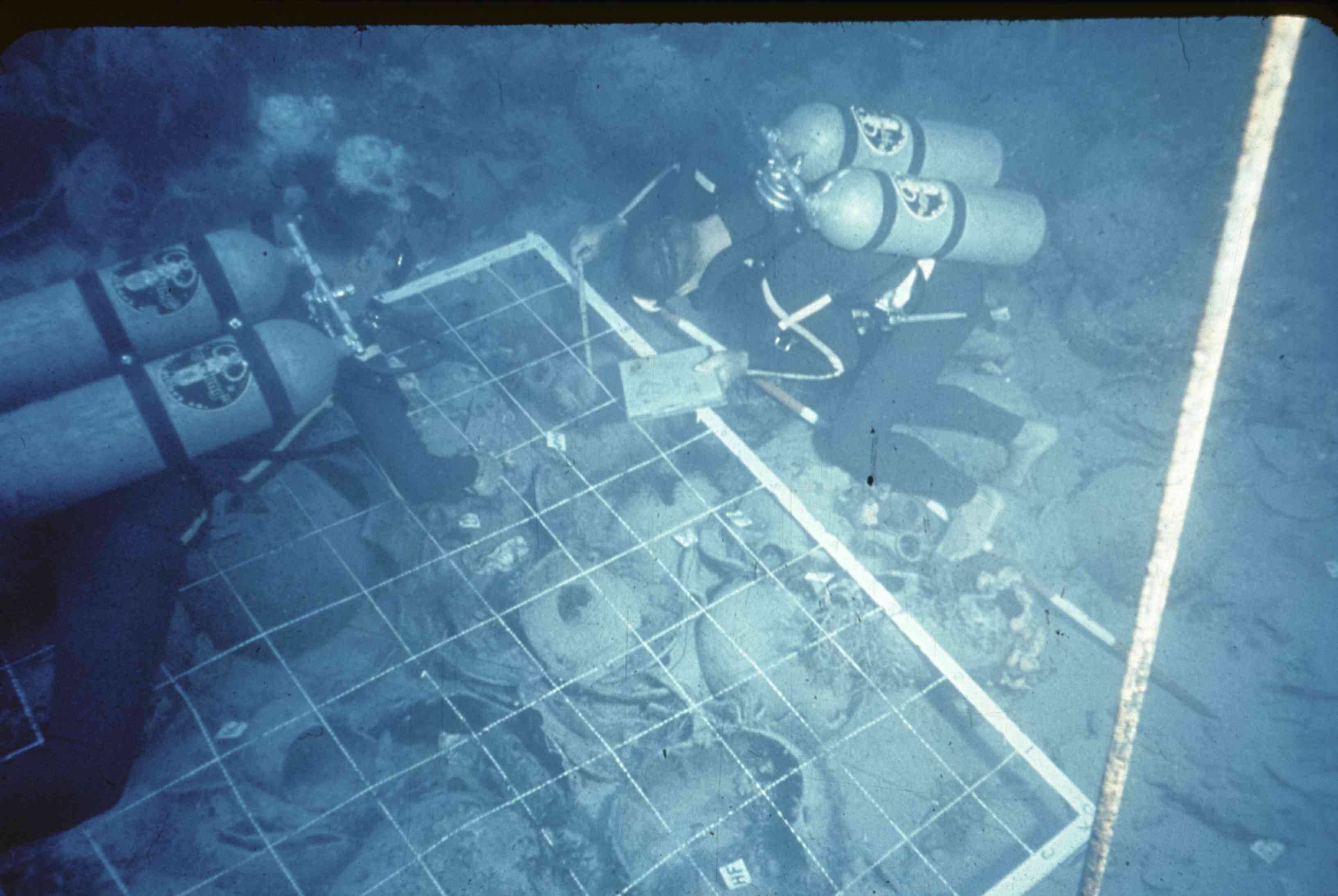
The excavation of the Byzantine ship at Yassiada took four summers and considerable trial and error. Given the limited time divers could spend underwater at great depths and the tendency for artifacts to drift away between dives, the goal was to collect data quickly so that detailed drawings could be made later above water. Depth measurements were the most difficult to obtain but also the most important for producing credible archaeological sections and elevations. In order to get these drawings right, the Yassiada crew invested significant time and energy developing a series of mapping machines that could measure depth in different ways.15
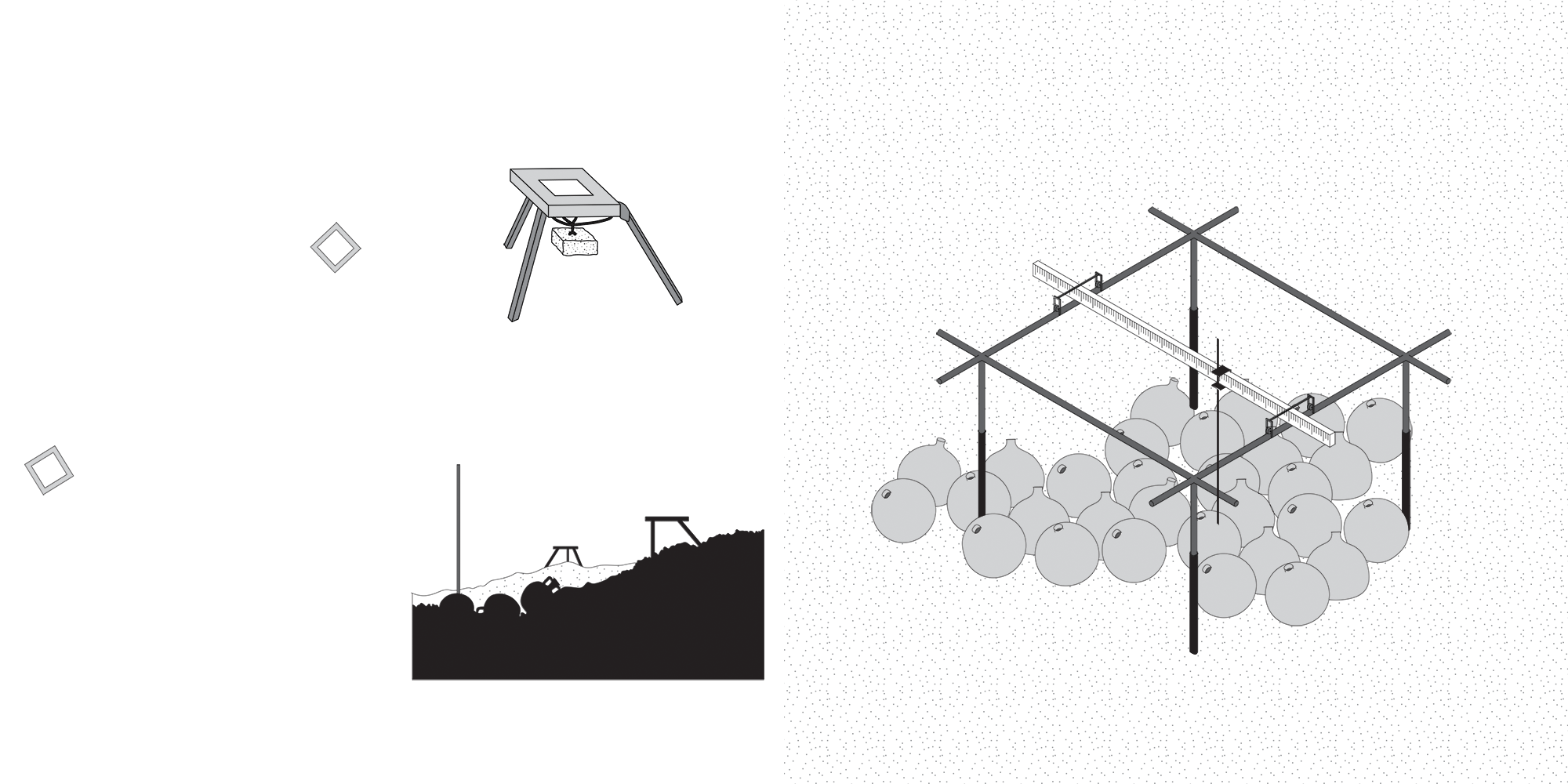
Right: Mapping Frame: For sectional measurements they erected a mapping frame with a sliding vertical rod, but it didn’t handle sloped terrain well and caused parallax.
Right: The Asherah: By 1964 they obtained a research submarine with two aerial cameras to produce photogrammetric maps of the entire site in just a few days.
Underwater draftsmen were also invested in developing new drawing typologies that could communicate the salient features of a shipwreck while still maintaining archaeological standards. Frost worked out a variety of underwater techniques using projective geometry that would allow her to translate a quickly drawn perspective sketch with certain crucial, known points into measured plans and sections above water. Dismissive of the idea that plans and sections should be the de facto forms of archaeological representation for shipwrecks, she described the differences between the representation of aquatic and terrestrial ruins:
Why, one wonders, is it necessary to divide the strange, collapsed machine which is a wreck into squares, and what is sacrosanct about vertically observed plans? They are essential to the understanding of a collapsed building, but are they the only convention that will explain a dislocated pile of machinery? If there is one thing that modern art taught, it is the multiplicity of visual conventions, each communicating a different type of statement and each depending on the limitations of the medium used.16
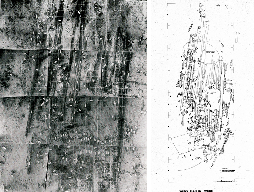
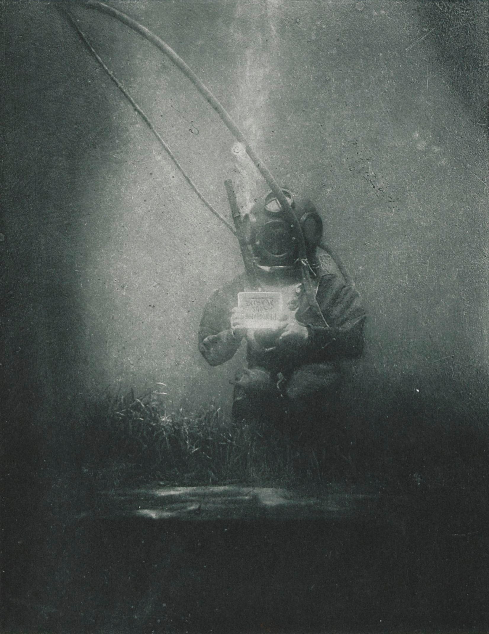
The drawings produced during the Yassiada excavation generated credibility within the archaeological community first and foremost because they looked like archaeological surveys and contained standard data sets. Despite their thorough documentation, it took decades for Bass to accurately parse out the ship’s construction and gain insights into its relevance within the history of shipbuilding.17 Since little remained of the original ship after their excavation, they had only their drawings and photo grids to study from in the decades to come. The mapping grid frame they erected, created to accommodate the limited reach of the underwater camera, helped to extrapolate and emphasize the relative connections and relationships between artifacts. With just this information left of the ship, they were able to make accurate models and replicas because they were thoughtful and considerate of the information they did collect. Even as their representation bestows particular readings of form or even ideologies of progress onto our understanding of the wreck, it still leaves holes or gaps where new readings might be possible.
When all you have left of a cultural artifact is its representation, important questions are raised about how to document its essence, how the survey can replace the artifact, or how the survey affects our reading of history. The tools that made this history visible for the first time have also changed the way we understand it, whether that has to do with the way in which artifacts are identified and documented or the new international and technological context into which their representation places them. Frost readily admits the difficulty of conveying archaeological imagery to others. She writes, “When I was trying to explain what the Byzantine wreck looked like to non-divers I had to draw reconstructions from my plans, as nothing else could give the general impression.”18 The underwater territory may be available for discovery, but only by those with access to advanced technology and cultural credibility with global institutions. The body of knowledge required to appreciate this history divorces it from its original context, forcing it to be read in another place by another culture. Furthermore, it is this mapping of a culture’s previous exploits, intended to reaffirm the identity and historical roots of the nation-state in which they are located, that instead upholds the idea that there is territory to be rediscovered.
Throckmorton’s night at a bar in Bodrum in 1958, or at least his depiction of it, exemplifies the problematic relationship between underwater archaeology and exploration in the postwar period. Toward the end of the book, Throckmorton tries to imagine the crew of the sunken ship at Cape Gelidonya and considers all the great explorers and geographers who had been to the Turkish coast before him. He writes:
I thought that surely we and our machinery would be unimaginable to these men, who would have recognized the islands and the cape immediately, but, unlike Strabo or Beaufort or Scylax, would find the jump from their time to ours, their life to ours, inconceivable. For they lived at the dawn of western civilization, and we in the twilight of it.19
In this sense, the spectacle of evolving underwater technologies in the 1960s is not to be understated. Underwater archaeology differs from archaeology on land for many reasons, but the most obvious are the physical and athletic obstacles posed for those carrying out their research. The image of the historian equipped with a wetsuit, oxygen tank, and waterproof flash-camera rig represents a new kind of explorer, one capable of conquering not only the dangers of the ocean’s depths but also what remains of the conquerors and civilizations of empires long since passed. As much as archaeological exploits were intended to produce a kind of shared global history after World War II, underwater archaeology in particular can be seen as a means for the West to claim the ancient past as its own, with the survey acting as a primary agent of this reclamation.
This scattered and inventive moment in the formation of underwater archaeology is especially important to reflect on today, as archaeological preservation has been pushed into new spheres with the rapid advancement and availability of high-resolution laser scanning and virtual reality. Recently there has been a rush to scan monuments in areas that are war-torn or subject to imminent damage from climate change, to harness information about their surface conditions in clouds of points that contain millimeter-specific coordinates with photographic color overlays. But even as we lose ancient monuments in cities like Palmyra, and as we feel compelled to build duplicate versions of places like the Chauvet caves, we should question our cultural tendencies to trust in the image of the archaeological survey. Given that today we are able to collect so much data in a short span of time, we should be ever more considerate of our technologies and of our methods of representation. As we continue to set new standards of practice, it’s worth looking back to hinge moments like this one in underwater archaeology or to major transitions in technological progress that are full of creativity and ad-hoc solutions to complex problems.
-
Peter Throckmorton, The Lost Ships: An Adventure in Undersea Archaeology (Boston: Little, Brown and Company, 1964), 15. ↩
-
This episode is recounted in the first chapter, “Pots in the Sea” in Throckmorton, The Lost Ships, 13–22. ↩
-
Throckmorton, The Lost Ships, 53. ↩
-
Honor Frost, Under the Mediterranean (London: Routledge, 1963), 121. ↩
-
Frost, Under the Mediterranean, 171. ↩
-
Sponsors for the 1961 Yassiada excavation included The University Museum of the University of Pennsylvania, the National Geographic Society, the Catherwood Foundation, the American Philosophical Society, the Littauer Foundation with a grant through Colgate University, Bauer Kompressoren of Munich, the Main Line Diving Club of Philadelphia, and Nixon Griffs. See George F. Bass and Frederick H. Van Doorninck Jr., Yassi Ada: A Seventh-Century Byzantine Shipwreck, volume 1 (College Station: Texas A&M University Press, 1982), 31. ↩
-
Peter Throckmorton, “The Discovery” in George F. Bass “Cape Gelidonya: A Bronze Age Shipwreck,” Transactions of the American Philosophical Society, Vol. 57, Part 8 (1967), 18; and “George Fletcher Bass, Ph.D.,” Institute of Nautical Archaeology, link. ↩
-
George F. Bass and Frederick H. Van Doorninck Jr., Yassi Ada, 3–4. ↩
-
Frost, Under the Mediterranean, 169. ↩
-
For descriptions of these methods see Eric J. Ryan and George Bass, “Underwater Surveying and Draughting—A Technique,” Antiquity, vol. 36, no. 144 (1962), 252–261; as well as Frost, Under the Mediterranean, 184–185. ↩
-
George F. Bass, “The Excavation,” in Bass and Van Doorninck, Yassi Ada, 31. ↩
-
Dimitri Rebikoff, “History of Underwater Photography,” in Underwater Archaeology: A Nascent Discipline, ed. Honor Frost (Paris: UNESCO, 1972), 197. ↩
-
Jean-Yves Blot, Underwater Archaeology: Exploring the World Beneath the Sea, trans. Alexandra Campbell (London: Thames and Hudson Ltd., 1996), 43. ↩
-
Blot, Underwater Archaeology, 45–46. ↩
-
A detailed description of all of these techniques can be found in George F. Bass, “The Excavation,” in Bass and Van Doorninck, Yassi Ada, 9–28. ↩
-
Frost, Under the Mediterranean, 181, 186–187. ↩
-
The ship, as it turns out, was much more interesting than they initially thought. Even though they used it as an opportunity to test out different mapping techniques, it ended up having a greater impact on our understanding of the Byzantine world than the older wrecks in the area they excavated later. The ship has been dated to the seventh century, and for many years Bass and his partner Fred Van Doorninck thought it was an ordinary merchant ship. Due to the damage inflicted by shipworms, very little of the original wood remained, but the stern of the ship had left its imprint in the sand when it wrecked. After carefully mapping the three-dimensional coordinates of its impression they could begin to extrapolate information about its construction. Many drawings and study models later, they were able to accurately replicate it. In doing so, they realized it marked an important moment in the history of shipbuilding because it combined ancient and modern construction techniques. Archaeologists had established two primary methods for building wooden boats in this historical period: one “shell-first” method—in which the shell of the boat was built first, and ribs were added to the outside after for strength—with the other being the more modern “skeleton-first” method, in which the ribs were built first and then clad with hull planks. The ship excavated at Yassiada turned out to be built shell-first on the bottom and skeleton-first on the top. Just as the excavation marked a transitional point in underwater technology and archaeological methods, the ship, too, represents an important bridge between the ancient and modern worlds. Blot, Underwater Archaeology, 63. ↩
-
Frost, Under the Mediterranean, 191. ↩
-
Throckmorton, The Lost Ships, 239. ↩
Gina Morrow is a designer at Guy Nordenson and Associates. She holds an M.Arch from Princeton University and a bachelor of arts in English from Vassar College.