
The following essay will appear in Climates: Architecture and the Planetary Imaginary, published this spring by the Avery Review and Lars Müller Publishers.
Anthropogenic climate change is a process unfolding on multiple scales at once, posing a challenge that is aesthetic as well as cognitive. Scientists have known for more than a century that changes in climate at local and regional scales can magnify global-average changes. For instance, the melting of polar ice reduces the reflectivity of the earth’s surface and allows it to absorb more heat, which accelerates global warming and increases local melting. Moreover, to describe the climate problem simply as “global” is to ignore the fact that responsibility for the buildup of greenhouse gas emissions is not evenly distributed across humanity, nor is vulnerability to the consequences of a warming planet. How then might we conceive and represent these multiple, interacting dimensions of change?
To pursue this question is to become aware of the ways in which political structures constrain the scalar imagination. As the legal theorist Michael Gerrard observes, there is a very narrow range of spatial scales on which legislation has addressed the climate problem.1 To put the issue in historical perspective: we live in the age of the nation-state, in which a single political model is so dominant that it has become difficult even to imagine governance on other scales, despite the fact that most of the world entered this epoch only recently, in the aftermath of the First and Second World Wars. The nation-state model constrains policymaking and even the study of climate change, since ecosystems do not respect political boundaries and science is often a national enterprise.2
By contrast, the term ecology was coined in central Europe in the 1860s, a historical moment marked by a diversity of state forms in Europe and throughout the world—the result, in part, of the reconfiguration of Europe and its empires that took place during and after the French Revolutionary and Napoleonic Wars, and that lasted until the consolidation of nation-states in the late nineteenth and early twentieth centuries.3 Even within individual states and empires in the mid-nineteenth century, there existed varying degrees of local autonomy.
Why does this matter for thinking about climate change? Because of the historical relationship between science and the state. As I have found in my current research, key elements of our present-day understanding of climate change—including our conception of the multiple scales involved—depended for their formulation on the structure of nineteenth-century states and the research they sponsored. It was principally in Europe’s continental empires before the First World War (in imperial Russia as well as imperial Austria) that climate came to be studied as a multi-scale system, from the dimensions of the planet to those of agriculture and human health.4 Until then, scientists had studied climate either as a planetary physics or as a local descriptive geography. The science that brought these disparate approaches together was dynamic climatology, the analysis of the transformation of typical air masses as they flow across the surface of the earth. The critical ingredients were nineteenth-century innovations in thermodynamics and fluid mechanics. In the place of the Enlightenment’s axially symmetric model of the global circulation, dynamic climatology mapped flows that became more complex as one zoomed in either spatially or temporally.5
My research focuses on the development of dynamic climatology in the Habsburg Monarchy, which covered nearly 700,000 square kilometers of central, eastern, and southern Europe in the nineteenth century, an area nearly twice as large as the reunified state of Germany today. With the decline of the Ottoman threat in the eighteenth century and the rise of cultural nationalism, the Habsburg dynasty was in search of a modern ideology of supranationalism. In the wake of the liberal-nationalist revolution of 1848, the dynasty increasingly legitimated its rule in central Europe on the basis of the emerging discipline of economic geography. Ministers and scholars in the service of the empire portrayed its territory as an organic system in which flows of air, water, capital, goods, workers, and information bound together its diverse regions. In keeping with the agricultural basis of much of the economy, the empire’s regions were defined, to a first approximation, by climatic difference. A metaphor borrowed from atmospheric science envisioned economic and cultural exchange as a circulation driven by the “evening out of neighboring contrasts.” This ideology set the agenda for many different fields of natural and social science in imperial Austria in the second half of the nineteenth century, including climatology, botany, geology, and ethnography. All were used as tools to flesh out this new “Austrian Idea” by studying the concrete conditions of (economic) unity in (environmental) diversity.
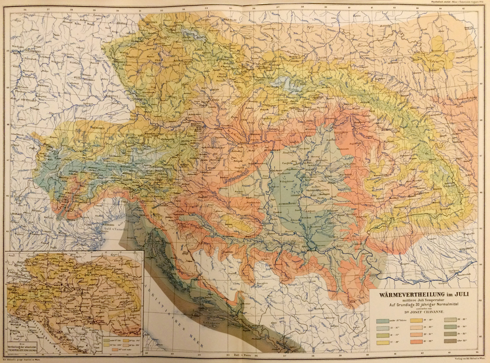
If we recall that the mathematical challenge of squaring the circle was known in Leibniz’s day as the Problema austriacum, then the conundrum of visualizing “unity in diversity” became the “Austrian Problem” for the nineteenth century.6 The challenge of representing local detail within an empire-wide overview propelled novel techniques in cartography. Consider the Physical and Statistical Hand-Atlas of the Austro-Hungarian Monarchy (1882–87), the first publication of its kind, which applied innovative methods for visualizing physical geographic and demographic (“statistical”) data. The challenge is easiest to grasp on the map of topographic elevation. As its creator put it, “Austria-Hungary in particular is a country in which one can clearly follow the interactions between the physical conditions of the land and the physical-cultural conditions of the populace; in both ways, the complex structure of the land offers a diversity of conditions of development and formation.”7 From this perspective, the ability to represent fine gradations of height might allow for a finer appreciation of cultural variation. But how was one to represent elevation on a map that encompassed the towering heights of the Alps and the monotonous expanse of the Hungarian plain? By the early nineteenth century, there were several methods in use for representing elevation, including hatching, contour lines, and profiles.8 What Habsburg cartographers pioneered was the use of color for the purposes of contouring, where it had previously been used to demarcate territorial holdings. Colors could be used to give an immediate visual impression of elevation, particularly on small-scale maps such as overviews of the Monarchy as a whole.9 It was not simply the application of color that distinguished the Austrian experiments in mapping elevation; it was the depth of theoretical engagement with the problem of representing vertical scale, resulting in the competing systems of Karl Hauslab and Karl Peucker, the latter based on studies of the physics, psychology, and physiology of color perception (a lively field of research in Vienna at the time).10 In the 1887 Atlas, the map of elevation employed Hauslab’s scheme, deviating only in the choice of pale blue for the highest peaks, the realm of eternal frost. In fact, color was used throughout the atlas to make legible neighboring contrasts of terrain, climate, economy, or culture on an exceedingly small scale.
The Austrian Problem cut clear across the natural and human sciences. In anthropology, linguistics, architecture, art history, and beyond, researchers were likewise setting out to document the Monarchy’s cultural multiplicity. This brings us to Vienna’s fin-de-siècle contributions to architectural theory. Architectural historians might be familiar with the conceptual legacy of the mid-century enterprise to preserve Habsburg art monuments, namely Alois Riegl’s concepts of Stimmung (mood or ambience) and “age-value.” They are unlikely to realize, however, that Riegl was articulating an aesthetic ideal shared by climatologists.11
Commonalities among these scientific and humanistic projects were overdetermined by their institutional histories, shared personnel, and mutual methodological influence. For instance, the director of the Vienna Administrative Statistical Office, Karl von Czoernig, oversaw research on topics ranging from ethnography to art history to climatology and public health. The new minister of trade, Carl Ludwig Bruck, whose vision of Austria’s economic geography would prove so influential, also directed the commission charged with preserving Austria’s art historical monuments. These projects shared a common grounding in the “positive” methods of natural history: art historians insisted on the direct observation of original works of art, not copies, and they valued these objects not merely as things of beauty but as clues to an evolutionary process.12 More importantly, these projects shared a politics. They rested, first, on the principle that no cultural or linguistic tradition was too minor to merit scholarly attention. As Crown Prince Rudolf insisted, “none of the crown lands of Austria-Hungary should be regarded as unworthy of a loving, detailed depiction.”13 Second, each of these sciences sought to study the cultural effects of vigorous mixing or exchange. In ethnography, for instance, the seminal three-volume survey by Karl von Czoernig charted a history of migrations across the Habsburg lands in order to demonstrate that the ethnic diversity of the monarchy reached down to such minute dimensions that no division of the territory along national lines was conceivable.14 Analogously, the Vienna School of Art History challenged the naiveté of Romantic-nationalist celebrations of folk art by revealing the hybrid histories of these traditions.15 As Alois Riegl later put it, using language that echoed the “dynamic” thinking of Habsburg climatology: “On the occasion when the unfamiliar meets the unfamiliar in a close and sustained relationship the process of development is set in motion.”16 Thus, in an era when nationalism was reconceiving historical research as a quest for authenticity and indigeneity, a largely forgotten project emerged in the human and natural sciences to focus attention instead on the complexity of cultural flows.17
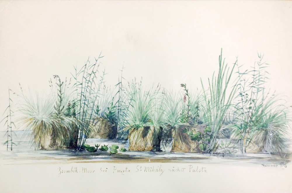
Although the term “monument of nature” [Naturdenkmal] was not yet in common use, the analogy between nature preservation and historic preservation was implicit in these “whole-state” surveys. This is well illustrated by the work of the plant geographer Anton Kerner, who set out to write a botanical history of the Habsburg lands, from alpine flowers to the grasses of the Hungarian steppe. Kerner suggested that it was the duty of the imperial-royal scientist to advance modernization and, at the same time, to salvage as quickly as possible what was left of traditional natural-cultural landscapes: “to preserve these last remains of authenticity [Ursprünglichkeit] in image and word.”18 Kerner took it upon himself to teach a German-speaking public to see the beauty of these “peripheral” landscapes, and he did so with lyrical prose and delicate brushwork.
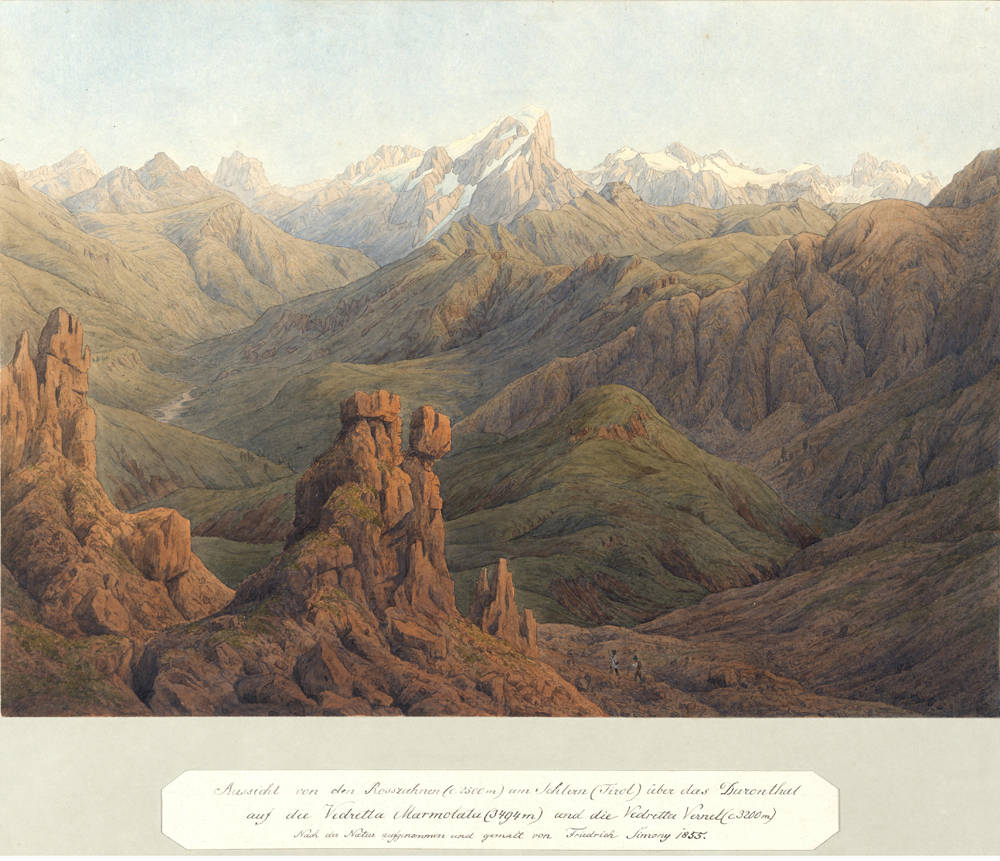
“Whole-state” research in the human sciences resulted in a host of cultural productions, from atlases to exhibits to memorials, all of which conditioned a new way of regarding a landscape. Alois Riegl termed it a “view from a distance.” He described the subjective effect as a “mood” or “ambience,” akin to religious devotion, yet awakened by the new scientific worldview, which saw a world interlinked by causal relations—the desire for “the comforting conviction of the unshakeable rule of the law of causality.”19 According to Riegl’s successor Max Dvorak, the quest for the synthetic overview derived from the artistic effort to capture “the diversity of natural phenomena … so that the full richness of the world down to the smallest wildflower and the most fleeting change in the atmosphere and quality of light has become a source of artistic sensations.”20 Dvorak’s description resonates with the aesthetic aims of Habsburg natural scientists, as we might illustrate by means of the famous alpine panoramas of Friedrich Simony.
Simony was the first professor of physical geography at the University of Vienna, and the first to insist that this discipline needed to take the entirety of the Habsburgs’ territory as its field of study. He described it as his duty to teach the public to see individual landscapes as part of this greater whole—in his words, to “awaken love and enthusiasm for the singular, beautiful, great fatherland” by means of “a life-like representation, from first-hand observation, of the most interesting and instructive natural phenomena from the diverse regions of the imperial state in word and image.” Technically, this necessitated a range of techniques for representing nature across dimensions of time and space: “panoramas and profiles, characteristic landscapes and images of individual natural historical points of interest or objects, then too graphical representations of various kinds,” all produced as posters “of the largest possible size” to be suitable for public lectures.21 In his panoramic landscape paintings, for instance, Simony perfected visual methods for capturing fine-grained detail within compositions that are, nonetheless, clearly legible as foreground, middle ground, and background.
In the 1890s, Alois Riegl introduced the concept of age-value [Alterswert] to describe the quality of historic monuments that defined their worth. Like Stimmung, age-value was linked to a view from afar, now in both the temporal and spatial sense, yet a view concerned with the specificity of individual objects and cultural landscapes. Just as the effect of Stimmung arose from an awareness of causal connections in space, age-value corresponded to an equally naturalistic vision of the cycle of universal birth and decay. Riegl imagined it as the view of the Habsburg subject traveling as a tourist within his own state: “the Bohemian searches to satisfy his deep longing for mood in something like a cathedral in Dalmatia, while a person from Styria finds it in Tyrolean wall painting, and the person from Silesia finds it in Salzburg’s Italianate architecture.”22 By the 1890s, Habsburg subjects had been trained to take such a spatially and temporally “distant” view of cultural landscapes. Their eyes had grown accustomed to the techniques developed by sciences like climatology, geology, ethnography, and art history for representing fine-grained detail within a large-scale overview. Riegl’s concepts of ambience and age-value should thus be understood as theorizations of a gaze that was cultivated jointly by the natural and human sciences under the patronage of the Habsburg state in the wake of 1848, a gaze associated with an important historical transition in the understanding of climate change.
Today, the climate crisis compels us once again to hone such a multiscalar vision. To do so, as this history suggests, we will need to transcend the political and intellectual constraints imposed by the borders between nation-states. But there is another lesson implicit in the history of the Austrian Problem, and that is the potential for the arts and sciences to reinforce each other’s efforts toward a new way of seeing. Rather than assuming a division of labor according to which the sciences provide “explanation” and the arts “understanding,” Habsburg scholars across the disciplines adopted a common ideal of Anschualichkeit or visualizability, and they held themselves to this high standard when communicating with the public. Thus the goal of climatology was to produce “a maximally life-like [lebendig] picture of the interaction of all atmospheric phenomena over a patch of the earth’s surface.”23 Jointly producing such a picture would be an equally worthy goal for artists and scientists today. Architects, in particular, are as skilled as climatologists in the creative work of up- and down-scaling.24 Their collective experience might hold the key to a new intuition for the multiple scales of climate change.
-
Michael Gerrard, presentation for Climate Change and Scales of the Environment, Columbia University Graduate School of Architecture, Planning and Preservation, December 2014. ↩
-
On scientific nationalism, see Carol E. Harrison and Ann Johnson, eds., Osiris 24, National Identity: The Role of Science and Technology (2009). ↩
-
Jürgen Osterhammel, The Transformation of the World: A Global History of the Nineteenth Century, trans. Patrick Camiller (Princeton, NJ: Princeton University Press, 2014), 573. ↩
-
On Russian agricultural climatology, see David Moon, The Plow that Broke the Steppes (Oxford: Oxford University Press, 2013). ↩
-
For an overview of the history of climate science since antiquity, see Matthias Heymann, “The Evolution of Climate Ideas and Knowledge,” Wiley Interdisciplinary Reviews: Climate Change 1 (2010), 581–597. ↩
-
William Ashworth, “The Habsburg Circle,” in Patronage and Institutions: Science, Technology, and Medicine at the European Court, 1500–1700, ed. Bruce T. Moran (Woodbridge: Boydell Press, 1991), 137–167. ↩
-
Josef Chavanne, “Höhenschichtenkarte,” in Physikalisch-Statistischer Hand-Atlas von Oesterreich-Ungarn (Vienna: Ed. Hölzel, 1887), ix. ↩
-
Max Eckert, Die Kartenwissenschaft: Forschungen und Grundlagen zu einer Kartographie als Wissenschaft (Berlin: W. De Gruyter, 1921), vol. 1, part 6, esp. 469. ↩
-
By contrast, elevation maps in Wilhelmine Germany tended to use a simple two-color scheme (green for lowlands, brown for mountains) and to neglect spot heights. Ingrid Kretschmer, “The First and Second Austrian School of Layered Relief Maps in the Nineteenth and Early Twentieth Centuries,” Imago Mundi 40 (1988): 9–14, 12. ↩
-
See my Vienna in the Age of Uncertainty: Science, Liberalism, and Private Life (Chicago: University of Chicago Press, 2007), ch. 5. ↩
-
Diana Reynolds Cordileone has demonstrated the influence of natural science on the Vienna School of Art History; here, I draw on her analysis but go beyond it to show a more fundamental common ground in the conditions for spatial research that derived from the structure of the supranational state. Diana Reynolds Cordileone, Alois Riegl in Vienna 1875–1905: An Institutional Biography (Burlington: Ashgate, 2014). ↩
-
Cordileone, Alois Riegl, ch. 2. ↩
-
Matthew Rampley, The Vienna School of Art History: Empire and the Politics of Scholarship, 1847–1918 (University Park: Penn State Press, 2013), 84. ↩
-
Peter Stachel, “Die Harmonisierung national-politischer Gegensätze und die Anfänge der Ethnographie in Österreich,” in Geschichte der österreichischen Humanwissenschaften. Bd. 4: Geschichte und fremde Kulturen, ed. Karl Acham (Vienna: Passagen Verlag, 2002), 323–367; Brigitte Fuchs, “Rasse,” “Volk,” Geschlecht: anthropologische Diskurse in Österreich 1850–1960 (Frankfurt: Campus, 2003), ch. 10. ↩
-
Matthew Rampley, “Peasants in Vienna: Ethnographic Display and the 1873 World’s Fair,” Austrian History Yearbook 42 (2011): 110–132. ↩
-
Cited in Cordileone, Alois Riegl, 99. ↩
-
Rampley, “World’s Fair,” 132. ↩
-
Anton Kerner, Das Pflanzenleben der Donaulaender (Innsbruck: Wagner, 1863), 28. ↩
-
Quoted in Bernd Euler-Rolle, “Der ‘Stimmungswert’ im spätmodernen Denkmalkultus-Alois Riegl und die Folgen,” 3, link. ↩
-
Max Dvorak, “Einleitung,” in Die Denkmale des Politischen Bezirkes Krems, ed. Hans Tietze (Vienna: Anton Schroll, 1907), xvii. ↩
-
Quoted in Albrecht Penck, Friedrich Simony: Leben und Wirken eines Alpenforschers. Ein Beitragzur Geschichte der Geologie in Österreich (Vienna: Hölzel, 1898), 12. ↩
-
Quoted and translated in Cordileone, Alois Riegl, 276. ↩
-
Julius Hann, Handbuch der Klimatologie (Stuttgart: J. Engelhorn, 1883), 3. ↩
-
Albena Yaneva, “Scaling Up and Down: Extraction Trials in Architectural Design,” Social Studies of Science, vol. 35, no. 6 (December 2005): 867–894. ↩
Deborah R. Coen is a professor of history at Barnard College, where she teaches modern European history and the history of science. Coen is the director of research clusters and curriculum of Columbia University’s Center for Science & Society and a member of Columbia’s Committee on Global Thought. She is the author of Vienna in the Age of Uncertainty: Science, Liberalism, and Private Life (2007) and The Earthquake Observers: Disaster Science from Lisbon to Richter (2013), both published by the University of Chicago Press, and co-editor of Intimate Universality: Local and Global Themes in the History of Weather and Climate (Science History Publications, 2006). Her current project is Climate in Word and Image: Science and the Austrian Idea, to be published by the University of Chicago Press.