
The (landscape) architect has, of late, been something of an infrastructural makeup artist. In cities internationally, an increasing number of architects and landscape architects are designing at the urban scale. It’s not a difficult development to support, opening up, as it does, defunct city spaces as parkland and public places. Although the High Line by Field Operations and Diller Scofidio + Renfro in New York, the first phase of which was completed in 2009, receives much credit for jump-starting popular interest in reconceiving old infrastructures as new public amenities, it wasn’t the first. Chicago’s Millennium Park was built atop the lakefront train yard in 2004 and has become one of the city’s more iconic landscapes. The project is simple—two levels of parking layered over train tracks with a park placed on top. Many have maligned the park as an unimaginative missed opportunity, as its overall planning design is rather unoriginal. The park instead relies on discrete elements that function well as individual objects. Pieces like Anish Kapoor’s “Cloud Gate” (aka the Bean, for obvious reasons) and Jaume Plensa’s “Crown Fountain,” attract visitors and set up interesting social space, but the landscape of the park is very flat and serves mostly as a background to the art. Each element is a little island to itself and the landscape prevents them from intermingling. Mixing programs and landscape could have led to more formal invention.
Now, after an eleven-year hiatus in which the city was momentarily distracted by a failed Olympics bid, Chicago is back to rethinking its under-utilized infrastructure and industrial past, opening three additions to the infrastructure-into-public-amenity category of projects: Maggie Daley Park, the 606/Bloomingdale Trail, and the Riverwalk.
Maggie Daley Park, a giant playground designed by landscape architect Michael Van Valkenburgh, is a new frenetic neighbor to Millennium Park, and like its neighbor, is built on top of an underground parking garage, which is in turn superimposed on a train yard and a landfill. (Interestingly, the landfill was created of debris from the Great Chicago Fire of 1871, when the city pushed its burnt downtown into the lake and created instant land.) Again, a public amenity is overlaid on a moneymaking program (a garage), itself overlaid on disused infrastructure (a train yard). Although there is no programmatic mixing or leveraging of infrastructure, the equation is an interesting one. The fees from parking are meant to support the free park on top. Whereas Millennium Park is a series of stacked plates of train tracks/parking/park, here the top-level park is made extremely topographic. In such a flat city, the effect is more intense than might be imagined. The park itself is a child’s dream, with three acres of themed play zones, climbing walls, gardens, and an ice skating “loop” in the winter. It is hard to compare this park with Millennium Park in terms of program, since the audience of each is extremely different, but one wonders what would have been the result at Millennium if its designers were this exuberant in their approach to section. 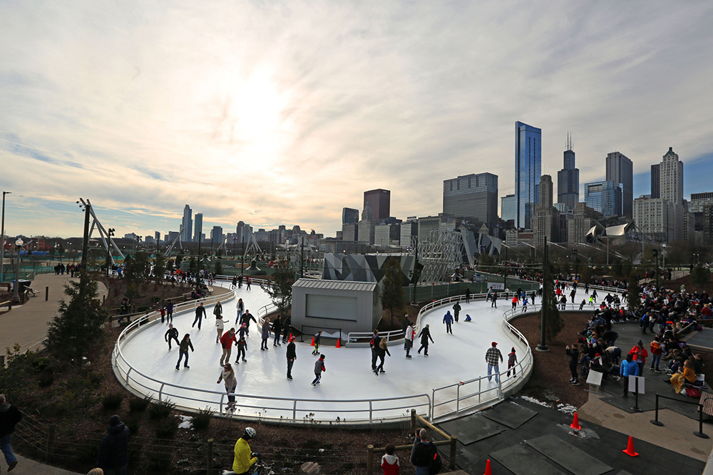
With the 606/Bloomingdale Trail, Chicago, taking a cue from New York, reconfigured one of its own abandoned urban train lines into an elevated linear park. The Bloomingdale Trail is longer than the High Line, and much less precious. A collaboration between Michael Van Valkenburgh and architect Carol Ross Barney, the old railway is reimagined as a series of simple moves—ramps of different lengths and proportions and simple straightaways—to bring people up and along a paved path outlined in a “Chicago blue” rubber edging that works hard to provide a graphic coherence to the project. Whereas the High Line is detailed to within an inch of its life, the Bloomingdale is happy to rely on a smaller set of simple design moves. And whereas walking on the High Line involves much looking down, whether to the Chelsea streets or bespoke planters, the Bloomingdale trail creates sightlines out past the path to the city and neighborhoods that the trail cuts through. It is a sidewalk in the sky. 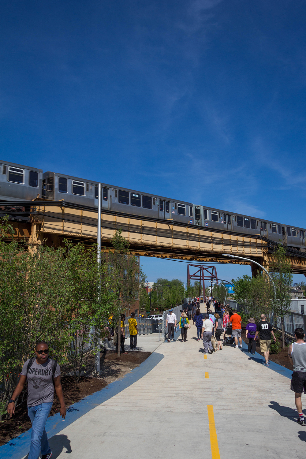
And then there’s Chicago’s Riverwalk by Carol Ross Barney and landscape architects Sasaki and Associates. Conceived of as a second waterfront for the city, the project creates a series of successful public spaces out of an assortment of handsome and precise surfaces including ramps, stairs, “stramps,” and platforms, providing venues for programs like performance, dining, and boating along the edge of the Chicago River. After turning its back on the river for a hundred years, the city is finally thinking about the possibilities of living, working, and recreating next to and on the river.
In all four Chicago cases, the existing infrastructure is essentially left alone or covered over with a thin layer of shiny newness. The projects range from extravagant and photogenic (Millennium) to understated and engaging (Bloomingdale). But none of them reconceive of infrastructure as something that will fundamentally improve the life of the city beyond the actual site of the project. And therein lies a missed opportunity.
In June, weeks after Chicago’s Mayor Emanuel cut the ribbon to the new extension of Chicago’s Riverwalk, it rained. The rainfall was substantial enough that the sewer supervisors were forced, as they often are during a big rain, to allow the sewer system to overflow into the Chicago River. Then they opened the locks and let the sewage flow out to Lake Michigan. This is standard procedure. It happens every year. A big rainfall in a city with a combined storm water and sewer system means that rainwater that falls in the city is always combined with raw sewage, creating a strain on the sewer infrastructure. And when the designated overflow is the river, as it is in Chicago, the river is inundated. Three weeks after the Riverwalk was opened to the public, it was covered with thousands of gallons of raw sewage.
And so we arrive at the question: Can we as architects and landscape architects design projects that actually propose better-designed infrastructure to work together with public program and public space? Could these urban-scaled projects be more by doing more?
There is precedent for this idea in Chicago. Architect Daniel Burnham’s 1909 Plan of Chicago sought to leverage new infrastructure to create public amenities and economic prosperity. The plan called for the lakefront to be improved and designed as public space, which it hadn’t been until that point. Burnham proposed to use innovative (for the time) infrastructure like a new regional road system, consolidated train lines for greater efficiency, and better-organized hierarchies of city streets to support public space and public programs (museums, libraries, and cultural centers).
For Burnham, the gambit was to mobilize infrastructure in the service of public space and public benefit. The current calculation in Chicago, and elsewhere, seems to be to dress up old infrastructure with a topcoat of public programming. The infrastructure is no longer functional—Bloomingdale’s abandoned train line, Maggie Daley Park’s unused train yard—or worse, it is badly designed: the Chicago River. And to be clear, the river is designed; it was reversed a hundred years ago by Chicago’s politicians and planners to avert a serious health crisis. In their hurry to make Chicago a major metropolis, Chicago’s leaders designed and installed the current combined sewer and storm water system. At the time it was more expedient to organize all water into one set of pipes than two. The city didn’t bother to clean the sewage and directed all its sewer water toward the river, which at the time was lined with plants and factories. The river flowed to the lake where the city pulled its fresh drinking water. As the city grew, this setup became problematic as wastewater contaminated drinking water. Attempts were made to move the water intake cribs farther and farther into the lake, but to no avail. The freshwater kept getting polluted, and the city leaders were growing worried. So the city decided to reverse the river and send its sewage to St. Louis. (St. Louis, of course, was not happy about this.)
In an infrastructural feat, the city dug a seven-mile canal that connected the Chicago River with the Mississippi River via the Des Plaines and Illinois rivers. Technologies developed for the project were subsequently used to dig the Panama Canal. In one masterful move, the city fixed (for a time) its water problem and opened up a whole new source of revenue by creating the only shipping canal to link the Gulf of Mexico with the Great Lakes and the Atlantic. It was an awesome twofer if ever there was one.
But that was then. Now the city has constructed a giant tunnel—imaginatively named the Deep Tunnel—that is supposed to redress the current sewage overflow and flooding. But the reason the city floods is because that first engineering move—to combine sewer and storm water and send it to St. Louis—is no longer the best infrastructural solution. This is where architects and landscape architects should insert themselves with big ideas that harness new infrastructure to solve planning problems and create public space at a large urban scale. What if flooding could be solved with public space rather than flooding compromising public space?
Of course, once city officials decide to dress up an old infrastructure with a layer of park, it is already too late in the game for the architects, landscape architects, and urban designers who work on these projects to recommend to politicians and city planners that they completely rethink the city’s infrastructure while working on a small slice of it. But we should try. We should propose infrastructures that can be leveraged for new social space and new possible lifestyles. If the city were to install a distributed network of water treatment that took waste water and storm water, and cleaned it “on site,” sewage would no longer need to be pumped into a super-energy-intensive system of waste water treatment plants and pipes that fill up and lead to overflow events that dump sewage into the river. These new infrastructures could be platforms for new public amenities beyond water cleaning, ones that use the water itself in a new network of cultural programs like natatoria or thermal baths, or a new network of water-intensive production that could take advantage of the surplus water like agriculture. Or, since we’re talking parks—a new network of public space. Or all of the above, designed together in new programmatic mash-ups. Water is not, of course, the only infrastructure that can and should be rethought; transportation and energy are also in need of attention. We should propose big ideas, because otherwise we will continue to design and build beautiful projects that are covered with dirty water every time it rains.
Sarah Dunn is an associate professor in the School of Architecture at the University of Illinois at Chicago and Martin Felsen is an assistant professor in the College of Architecture at the Illinois Institute of Technology. They are the cofounders of the architecture and urban design office UrbanLab.